
The Seven Towns of Otmoor

The first record of Ot Moor by name appears in an undated charter drawn up between 1006 and 1011 by which King Æthelred II granted to a Dane called Toti five mansi at Hortun and one at Beccalege (Horton and Beck-ley?). This was preserved in the Red Book of Thornley. The bounds of the lands are described as:
" ... up of there ealden ea in to ottanmere. Of ottanmere thuyrsover bugen-roda. of bugeroda into maer mer. of mearmere on merthorn .. "
Bugenroda may be the Roman road and Maerthorn or Maermere may have been Marlake. The lands were probably what is now Horton cum Studley, Beckley and Whirtecross Green, west to the Roman road. This is also the first mention of Horton or Hortun as a village.
The Roman occupation goes back to at least AD95 following dendrochronological examination of piles at a crossing point on the river Ray in Fencott. In the Roman period up to AD410 bronze and Iron metal work would have been carried out and pottery made locally. From the Roman tiles found it is likely that there were substantial Roman period buildings on the high ground while subsistence farming took place on the fertile lower ground. Fresh water shellfish were certainly on their menu as many shells can be found in the area. There have been numerous finds of Roman coins, brooches and other artefacts around the moor.
One fragment of limestone is all that remains of 'Joseph's Stone' once thought to be a Roman mile-stone, it lies near the centre of the moor. The Roman road crossed Otmoor from Fencott to Beckley, and a track crossed that road from Oddington to Horton cum Studley.
Local tradition, however, says that the stone was used as a mounting block for farmers heading to the moor to round up their animals. Joseph’s, or Jacob's Stone is mentioned in an inscription featured in the Bodleian Library that reads:
'Jacob's stone of high renown,
To help me up when I am down,
On my way to the Seven Towns'.
The remains of a Roman Timber bridge was found at Ivy Farm in Fencott.
Horton cum Studley
Hor = muddy, tun = place, cum = with
Stud = place for horse, ley or leah = clearing in wood or little wood
Horton cum Studley is virtually on Oxfordshire's border with Buckinghamshire and on the south-east edge of Otmoor. It was formerly two separate parishes, (surprisingly, named Horton and Studley). Studley was historically partly in Oxfordshire and partly in Buckinghamshire and was only reunited when the Buckinghamshire part merged with the already existing Oxfordshire parish of Horton cum Studley in 1932.
At the foot of Horton Hill is the church of St. Barnabas, built in 1867 and designed by William Butterfield, the famous architect of Keble College, Oxford.
About half way down (or up) the hill is Studley Priory, a large 16th century house built on the site of an earlier Benedictine priory. R.M. Marshall’s 1935 Oxfordshire Byways describes the view from the Priory:
‘In their seclusion the Benedictine sisters saw the herds of cattle feeding in the green pastures, and in the winter flood-time they watched the wild duck winging its way. On May-day year by year they welcomed the men of Charlton who came across the moor to the Priory, carrying with them the image of the Virgin, the patron saint of the convent and their church. The herdsmen of the district paid them a tithe of their beasts and their cartulary contains a description of that land of Otmoor which was held in common by the dwellers in the seven towns. It is so great and notable a quantity of ground, so beneficial a common, so profitable for fowling and fishing to all the inhabitants of six or seven townships, bordering round it…who have ever used and enjoyed the right of common for all their flocks of sheep, herds of beasts and all manner of cattle at all time, and have taken and enjoyed the fishing and fowling at their pleasure at all times, none of the said townships claiming any pre-eminence or greater right than the rest.’
At the time of the Reformation, the reigning Prioress could not prevent the dissolution of the priory, and in November 1539 she signed the deed of surrender to the king, and left the priory with the remaining nuns.
In times past the local crops were blessed at Ascensiontide and a Feast was held which lasted for three days with cricket matches and a small fair. Horton now holds a half marathon, fete, and hog roast in its place.
Murcott
Mur (mere or moor) marshy area, cott = cottages
Church Way, the track from Murcott to Fencott and on to Charlton-on-Otmoor was first mentioned in 1469. The church rolls of this low-lying village frequently mentioned overflowing ditches and flooded roadways. Not much has changed. Most of the land here was held by Westminster Abbey as part of Islip Manor.
Local By-laws (Translation from the original Latin), 26 April 1502:
"It is commanded that each tenant of Murcot having land in the place called Heycote Furlong and in another place called Mabyldon Stubble cultivate it sufficiently at the proper season. Pain 3s 4d on each them defaulting.
Of the old field names, a few are particularly interesting: Struttle Mead (reminiscent of Street Hill, the local name for the Roman Road) and Sweetingal Furlong (Sweetingal is a species of bog-myrtle which grew in local bogs). The piece of land opposite Poplar Farm in Fencott was known as “Splash” (self-explanatory).
The Nut Tree Inn, which received a Michelin Star in 2009, is a thatched building dating back to the 15th century. The Murcott Mission Room was built in 1895 to a plain 'Early English’ design by local Gothic Revival architect A. Mardon Mowbray.
Otmoor, a very low-lying fen, with several treacherous marshy spots, is imbued with folk tales, including ghosts of drowned men trapped in a bog when crossing the moor at night, nocturnal beasts snatching livestock, and strange ailments waiting to be caught by travellers.
If Otmoor does contain bottomless mires from which walkers who fall in never escape, no one has survived to say where they’re located...
You’d best beware!
29th April 2017, Oxford Mail: Mum-of-two Lisa London from Bicester says she saw a big cat crossing the road in Upper Arncott
A MUM-of-two believes she is the latest person to spot Oxfordshire's most famous big cat. Lisa London says she saw a panther-like creature stroll across the road in front of her in broad daylight on Tuesday morning. She joins a long line of people go-ing back to the 1990s (at least one from Horton!) to see what they swear is a big cat stalking the wilds of west and north Ox-fordshire which was once dubbed the ‘Beast of Otmoor.’
Fencott
Fen = long narrow boggy area (probably the Roman Road)
cott = cottages
Local By-laws (Translation from the original Latin),1 April 1421:
It is agreed here be the court that the tenants of Murcort and Fencot meet to determine the boundaries and metes in the fields there before the feast of St Philip and St James the apostles next. Pain of 12d on each defaulter and for each default.
There were several public houses in Fencott which no longer exist: The Black Bull at the entrance to the village (near Black Bull Lane…), and The Ramping Cat by the pond.
It is said that the stone drain-pipes still used for draining the fields are of Roman origin, as are many of the stones in the stone walls. The remains of a Roman timber bridge were found under water in the village in 1979.
Scuttle – an Eel Basket
to Kype – to wade in the stream and catch fish.
There are still fish and otters in the River Ray.
But please
No Kyping!
The remains of a Roman Timber bridge was found at Ivy Farm in Fencott.
Charlton-on-Otmoor
Charlton meaning tun of the ceorls or Freemen
Land of the Free Peasants – the village has prided itself on never having owed allegiance to a lord of the manor. Charlton never had a resident squire or large land owner. Charlton-on-Otmoor is the largest of the Seven Towns and the last to be enclosed.
The domestic buildings are mainly of stone dating from the 17th century onwards. Most of the open field remained intact until 1858 and the farms remained in the village nucleus. There have been no outlying farms.
The centre of the village is dominated by the large 13th century Church of St. Mary the Virgin with its tall tower built on the site of an older structure. Substantial alterations were carried out to the church in the 14th century and there has been some further restoration since. The 15th Century rood screen has finely decorated carved panels.
Several industries were carried out in Charlton. Oxfordshire Waggons (yes, there are two g’s in waggon!) were made here (but repaired in other villages, notably Beckly.). The waggons were assembled where the current bus garage is, and the wood yard was across the street. The waggons lasted a lifetime – and even longer. There was a quarry at the western end of the village built on an outcrop of rock, and brickworks using local clay were established toward the end of the 18th century, possibly in the field known as Brickhill or Clayhill on the Fencott side.
Blackwater, or peat water wells were found on the eastern side of the village, its source probably being the fields between Merton and Fencott. Legend has it that a horse and cart were swallowed up in this boggy field along with their driver. (Please be very careful at this end of the village!) This black water was prized for curing Moor-evil, caught by livestock grazing on the moor, and for treating people’s eczema and sore eyes, but apparently it was of no use for making tea “as it frothed up when boiled.”
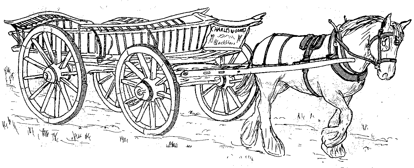
An Oxfordshire Waggon
An Oxfordshire waggon like this one, was built by Pullin in 1889, a wheel-wright of Charlton-on-Otmoor, for Mr. V.W. Tompkins who used it at New Inn Farm, Stanton St. John. It was acquired by Oxfordshire Museums from Mr Tompkins’ grandson. The Tompkins waggon is long boarded with elm planks which run the full length of the bed. It has spindled and boarded sides and the out raves are also spindled. Unlike the Jones waggon the Tompkins waggon has iron axle arms these were introduced in the latter part of the nine-teenth century as they were harder wearing than wooden ones. The Tompkins waggon also has iron tyres and is a half lock waggon. The wheels are also dished, this adds to their strength. The wheels have strakes, sections of tyre, nailed into place around the rim of the wheel, rather than having a continuous iron tyre. Strakes enable the wheel to be re-shod without recourse to a wheel-wright. Waggons have large wheels in order to pass over soft and uneven ground. Large wheels, however, give a restricted turning circle. To improve this, an inset is built into the side of waggons to allow greater wheel move-ment. Local waggons were typically painted with a yellow body and wheel-wright’s red for the undercarriage, wheels, shafts and body interior which are the less showy, harder wearing parts. At the end of the nineteenth century and into the early twentieth century a lighter vehicle, the trolley, began to replace the large and grand farm waggons. These were smaller and had a flat bed un-like the high sided traditional waggons.
The Otmoor Garland
Charlton-on-Otmoor Church is dedicated to St. Mary the Blessed Virgin and dates from the 13thc (though on the site of an earlier church). Before the Reformation (16thc) the wonderful Rood screen (that separates the Nave with its pews from the chancel) was decorated with large statues of The Blessed Virgin, St.John, and the Crucified Christ.
Once a year the statue of Mary (known as Our Lady of Otmoor) was carried in procession from the church around the moor to Studley Priory (Horton-cum-Studley). This recreated the old legend that Our Lady rode round the moor carrying a burning oat sheaf and the area she covered, while it burned, was given forever to the people of Otmoor.
During the Reformation puritans destroyed the statues, and they were replaced with garlands. Dunkin’s History of 1823, contains an engraving showing these two garlands and a description of the rood screen:
The roodloft shows two large hooped garlands of flowers, appropriately surmounted with crosses, conveying a faint impression of its former appearance, when decorated with its massive crucifix and the attendant figures (large as life) of Mary and John.
An engraving in 1840 shows only one garland, and in 1854 that one had been removed. However, when the unsympathetic Reverend Mr. Riggs departed, the villagers promptly replaced the garland.
The garland and its cross were taken down each year before the village feast day, September 19th, and dressed with box clippings. For May Day “her dress” was adorned with spring wild-flowers.
The procession of the garland continued until 1857. It was carried from the church in Charlton-on-Otmoor to Studley Priory in Horton cum Studley, accompanied by Morris dancers and Charlton villagers. Charlton Primary School keep the tradition of the Garland alive today, decorating the church each May with a long floral garland fixed to the Rood screen.
Today, recalling Our Lady of Otmoor’s gift of the moor itself to us, we once again carry a garland from Charlton church to Studley Priory.

Artist: Nicholas Mynheer
Oddington
meaning Otta's Dun or Hill – probably the same Otta who gave his name to Ot moor
In 1138 Robert le Gait founded a Cistercian Abbey at Oddington. The land he gave to the Cistercians was however described as "fitter for an ark than a monastery". When Robert le Gait's monks could no longer tolerate the wet conditions on Otmoor, they moved to the abbey church at Thame Park, sometime between 1138 and 1142. The building appears to have remained as the Bishop gave consent for Thame Abbey to continue to hold services at Oddington (providing the parishioners were excluded!). Local legend says that the old monastery was close to the church, though it’s more likely it was outside the village at what is now Oddington Grange. A Saxon graveyard was discovered in Brinsmere field near the old Rectory to the north
There are two medicinal wells in Oddington. Their water was used to cure the so-called potentially fatal moor-evil contracted by cattle, but luckily not by humans. The water can also be used as a remedy for sore eyes if anyone feels the need (though it’s not to be recommended…!).
Ducklings splashed in the pools, fish abounded in the streams, and though damp mists from the undrained marsh brought ague to humans and moor-evil to cattle Oddington people consoled themselves with the belief that they had an unfailing remedy in the water. – Oxfordshire Byways, R.M. Marshall
The Church of St Andrew sits on the edge of Oddington, on the site of the former medieval village. No other buildings from this period remain, but their outline can be seen in the field behind the church. The church dates from the late 13th to early 14th century although major restoration was carried out in the 19th century. At the west end there is a pieta decorated with Maori totems commemorating Maori soldiers who died in the First World War. This was put up by Maggie Papakura, a Maori princess, who lived in the village. Her grave is in the churchyard. In the churchyard there is also a 14th century stone preaching cross.
Grave of Maori Princess, Maggie Papakura
Noke
Otan-ock = place of the Oak
Noke dates from late Anglo-Saxon times when it would have been a clearing in extensive woodland. The parish still has two woodlands: Prattle Wood about 500 yards (460 m) southwest of the village, and Noke Wood about 1 mile (1.6 km) to the southeast.
It is said that Noke was used by members of Oxford University as a refuge to escape the plague during the fifteenth century.
Part of the parish of Noke was included in the original grant, as fees of Islip, made by Edward the Confessor to the church of St. Peter at Westminster, and until 1800 the people of Noke had to attend the reading of certain documents in Islip Church. There was a lane called Church Way, now overgrown, between the two villages. Those villagers in Noke who paid tithes to Islip’s parish church were buried in Islip churchyard, and to this day the path is known as the “wake” or “coffin path.”
Noke had a parish church by 1191, but the present church of Saint Giles dates from the first half of the 13th century. The font is reputed to have been a gift from Princess Gundreda, youngest daughter of William the Conqueror At the end of the 16th century a mortuary chapel was added for the Winchcombe family, but in 1745 the chapel was demolished. There is a tradition that says the head of Winchcombe’s effigy was taken from the ruins and placed on a wall behind the church where it was used for target practise by the village boys. It was later brought, slightly battered, into the church. Another story relating to Benedict Winchcombe, an avid huntsman who died in 1632 and whose tomb is at St Giles’s, says that on wintry nights he and his hunt still gallop through the village if anyone is brave enough to listen out for them. They are also known to appear on sunny afternoons in early July.
Noke had a thatched school, built in 1863 and closed in 1946. There also used to be a public house, but unfortunately this too has closed. The village contains a medicinal well (there are two more in Oddington if you are in need), whose water was used as late as 1900 to cure livestock - and human beings.
Beckley
Becka's leah or Becka's clearing in a wood.
The village is built along Roman road (Sand Path) and nearby the remains of a Roman villa were found. There is a reference to the village in the Doomsday Book, where it is listed as Bechelie, Oxenefscire. Many of the honey coloured stone cottages date from the 16th, 17th and 18th century.
At the time of the Norman Conquest William the Conqueror gave the manor of Beckley to Robert D’Oilly. Nothing remains of the former palace of Beckley, or of the deer park enclosed in 1197. Down towards the moor to the north-east is Beckley Park, a beautiful brick house built around 1540 by Lord Williams of Thame, as a hunting lodge. The history of the site, however, and of the three moats goes back many centuries before that. King Alfred once owned it and the triple moats date from the ninth century. The present house was built between the outer and middle moats.
There has been a hostelry in Beckley since the days of Charles II. In 1723, the wife of the landlord of The Royal Sun was placed in the stocks for causing a disturbance in the village. Her husband John was ordered not to sell wine, and was fined for being disorderly. Today the pub has changed its name to The Abingdon Arms and is only a bit less raucous.
The village church is the Church of the Assumption of the Blessed Virgin Mary, partly Norman, partly 14th and 15th centuries. The church is fortunate to retain some wall paintings, including a rare painting of the Virgin Mary suckling the baby Jesus.
There were two schools for orphans opened in the early 1880’s in Beckley: Old Ridge for boys, near the church, and New Ridge, further down the street, for girls. At the other end of the village there was a saw-pit, a smith, a joiner, and a coffin maker. At this end of the village was also the Oddfellows Barn where until 1914, on the last Thursday in July, a feast was held. There remains one old Oxfordshire waggon shed and the old smithy which is now a garage.
